Running is not only a great workout, but it is also a great way to release stress. Any runner you talk to could tell you about what is often referred to as a “runner’s high”. This is backed up by science too, according to a study published by Medicine & Science in Sports & Exercise in 2006, running releases a group of hormones called endocannabinoids that relieve feelings of anxiety and depression as well as helping you sleep and concentrate better.
On top of all this, running is a great way just to explore Golden in the beautiful fall weather. Here are some of the best places to get in a run without out having to drive from campus. Enjoy your run!
Something Flat:
If you want to run something that is flat, Clear Creek is your best option. Heading west up the creek and into Clear Creek Canyon gives a beautiful run that has the great benefit of being slightly down hill on the way back. Running up the canyon gives you up to 1.5 miles on trail each way. You can also choose to go east on the trail, which takes you on a cement bike path that parallels Highway 58.
How to get there: Run down on Maple St. and turn right when the road ends, cross the foot bridge that you will see and go either east or west.
Hills and Great Views:
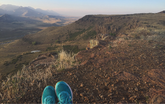
North Table and South Table are both great runs from campus if you are willing to endure the short and steep climb (both are about half a mile of AGGRESSIVE up hill). Although, once you get to the top it is all worth it! There are great views of both the mountains and downtown Denver that are especially stunning at sunrise or sunset. Also, once you get to the top, the tables are both relatively flat, with some nice rolling hills. Note that North Table is a significantly longer run than South Table, if you are running from campus it is 3 miles to the trailhead parking lot for North Table.
How to get there:
South Table: Go own either down 19th street and at the end there will be a gate/fence with a trail on the right, and just go up that. Once you get to the top, heading right/east is a particularly nice route.
North Table: Go east on the Clear Creek path, but instead of following along Highway 58, go under it, and go up the concrete bike path (this is formally called “Tucker Gulch”). Follow that until you hit Highway 93, and then go north on the path (do not go under 93) and you will reach the North Table Trailhead.
Note: Be especially careful about rattlesnakes on the tables. It is really common to see then up there and if you are running, especially with music, you are at a higher risk of not noticing them. Also take caution when coming down the tables, they are equally steep coming down.
Going Long:
In this case, long means around 13 miles. This is a nice route that is on trail for about half of it. One major bonus of this route is that the last 4 or 5 miles are all a nice downhill. There is a park at about 4 miles with bathrooms and a drinking fountain and there are also bathrooms and a drinking fountain at the North Table. This run is especially nice for long runs because there are a lot of spots to add on extra mileage. You can also switch it up and just run up North Table if you are feeling extra crazy!
How to get there:
Go east on Clear Creek and follow the path until you can turn right to go under highway 58 on W 44th Ave (note this is not the same turn as to get to North Table trailhead), if you got across a large bridge, you just barely missed the turn. Follow the sidewalk until you can turn left on Salvia street (after the railroad museum but before you cross the train tracks). Right before you hit the park (there is water there), the trail will be on your left. Follow the trail (you will have to cross one road) and it will take you to around the back of North Table. Once you hit W 58th Ave, you want to turn left and run along this road until you reach the next trail that is just past an equestrian center. Once you are on that trail, it will take you back towards the North Table trailhead if you stay on the North Table Loop.
If You’re Insane:
This run is for if you are up for an adventure because you quite literally run up a mountain. Chimney Gulch trail offers great views and you will feel extra accomplished after getting to the top. This is also a great option if you don’t want to run, but would rather just hike! Also, if you are looking for something really long, this trail has a lot of options for adding on once you get to the top, just check out a map.
How to get there: Go towards Mines Park on 19th, and turn right on Pinal Rd, which becomes Mt. Zion Dr. After about half a mile you will see a dirt trail between two houses on the right, turn on that and it will take you to Chimney Gulch trail. Turning left/uphill will lead you to Windy Saddle, which is just a little south of the M.
Disclaimer: Look at a map before you run on a new trail and let someone know where you are going and when you plan to be back! Always play it safe on trail runs, especially if you’re going to run a distance that makes emergency care hard to access.
'Hitting the trails: A short guide on the best places to run from campus' has no comments
Be the first to comment this post!